


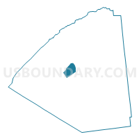
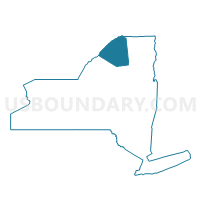
Voting District 020005, St. Lawrence County, New York
About
Outline

Summary
| Unique Area Identifier | 636349 |
| Name | Voting District 020005 |
| County | St. Lawrence County |
| State | New York |
| Area (square miles) | 27.08 |
| Land Area (square miles) | 26.82 |
| Water Area (square miles) | 0.26 |
| % of Land Area | 99.03 |
| % of Water Area | 0.97 |
| Latitude of the Internal Point | 44.54469500 |
| Longtitude of the Internal Point | -75.16754520 |
Maps

Graphs
Select a template below for downloading or customizing gragh for Voting District 020005, St. Lawrence County, New York


Neighbors
Neighoring Voting District (by Name) Neighboring Voting District on the Map
- Voting District 020001, St. Lawrence County, NY
- Voting District 020006, St. Lawrence County, NY
- Voting District 020007, St. Lawrence County, NY
- Voting District 020008, St. Lawrence County, NY
- Voting District 060001, St. Lawrence County, NY
- Voting District 130001, St. Lawrence County, NY
- Voting District 310001, St. Lawrence County, NY
Top 10 Neighboring County Subdivision (by Population) Neighboring County Subdivision on the Map
- Canton town, St. Lawrence County, NY (10,995)
- De Kalb town, St. Lawrence County, NY (2,434)
- Russell town, St. Lawrence County, NY (1,856)
- Hermon town, St. Lawrence County, NY (1,108)
Top 10 Neighboring Place (by Population) Neighboring Place on the Map
Top 10 Neighboring Unified School District (by Population) Neighboring Unified School District on the Map
- Canton Central School District, NY (11,821)
- Edwards-Knox Central School District, NY (3,401)
- Hermon-DeKalb Central School District, NY (2,645)
Top 10 Neighboring State Legislative District Lower Chamber (by Population) Neighboring State Legislative District Lower Chamber on the Map
Top 10 Neighboring State Legislative District Upper Chamber (by Population) Neighboring State Legislative District Upper Chamber on the Map
Top 10 Neighboring 111th Congressional District (by Population) Neighboring 111th Congressional District on the Map
Top 10 Neighboring Census Tract (by Population) Neighboring Census Tract on the Map
- Census Tract 4926, St. Lawrence County, NY (6,060)
- Census Tract 4920, St. Lawrence County, NY (5,299)
- Census Tract 4918, St. Lawrence County, NY (4,540)
- Census Tract 4921, St. Lawrence County, NY (4,239)
- Census Tract 4919, St. Lawrence County, NY (1,457)